Tuesday 28 March 2017

Pakistani administered Azad Kashmir


Kashmir is One of The Most Attractive and beautiful Area of Subcontinent 


Azad Jammu and Kashmir, often called paradise on earth, has a lush green mountain region North of Pakistan. At the time of independence of Pakistan, all Muslim majority areas wanted to be part of Pakistan. Kashmir, an 80% Muslim majority region did not become part of Pakistan. Currently, Pakistan administered 1/3rd of Kashmiri area, also known as, Azad Kashmir. Kashmir is the northernmost geographical region of South Asia. Until the mid 19th century, the term, Kashmir, denoted only the valley between the Great Himalayas and the Pir Panjal mountain range. At the time of the Partition of India, in 1947, the British abandoned their suzerainty over the princely states, which were left with the options of joining India or Pakistan or remaining independent. Hari Singh, the maharaja of Jammu and Kashmir, wanted his state to remain neutral. Muslims in Western Jammu province, current day Azad Kashmir, and the Frontier Districts Province, current day Gilgit Baltistan, had wanted to join Pakistan. Today, it denotes a larger area that includes the Indian-administered territory of Jammu and Kashmir, subdivided into Jammu, Kashmir, and Ladakh divisions, the 
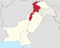
Pakistani-administered territories of Azad Kashmir and Azad Jammu and Kashmir abbreviated as AJK and commonly known as Azad Kashmir, is a self-governing administrative division of Pakistan. The territory lies west of the Indian-administered state of Jammu and Kashmir, and was previously part of the former princely state of Jammu and Kashmir, which ceased to live as a result of the first Kashmir war fought between India and Pakistan in 1947.

Azad Kashmir is part of the greater Kashmir region, which is the subject of a long-running conflict between India and Pakistan. The territory shares a border with Gilgit Baltistan, together with which it is mentioned by the United Nations and other international organisations as, Pakistan-administered Kashmir.The territory also borders Pakistan's Punjab province to the south and Khyber Pakhtunkhwa province to the west. To the east, Azad Kashmir is kept separate from the Indian administered state of Jammu and Kashmir by the Line of Control, the de facto border between India and Pakistan. Azad Kashmir has a total area of 13,297 square km, with an estimated population of around 4.6 million people. The territory is under a parliamentary form 
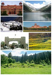
of government modeled after the Westminster system, with its capital located at Muzaffarabad. The President of Azad Kashmir is the constitutional head of the state, while the prime minister, supported by a Council of Ministers, is the chief executive. The unicameral Azad Jammu & Kashmir Legislative Assembly elects both the prime minister and president. The state has its Supreme Court and a High Court, while the Government of Pakistan's Ministry of Kashmir Affairs serves as a link between it and Azad Kashmir's government. Neither Azad Kashmir nor Gilgit Baltistan elects members to Pakistan's National Assembly.

The 2005 earthquake killed 100,000 people and left another three million people displaced, with widespread devastation. Since then, with help from the Government of Pakistan and foreign donors, reconstruction of infrastructure is in progress. Azad  Kashmir has been agriculture which meant that land was the main source or mean of production. This means that all food for immediate and long term consumption was produced from the land. The production included various crops, fruits, vegetables etc. Land was also the source of other livelihood necessities such as wood, fuel, grazing for animals which then turned into dairy products. Because of this land was likewise the main source of revenue for the 
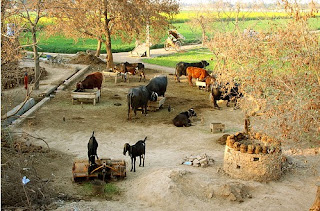
governments whose primary purpose for centuries was to accumulate revenue. Agriculture is an important part of Azad Kashmir's economy. Low-lying areas that have high populations grow crops like barley, mangoes, millet, corn, maize, and wheat, and also raise cattle. In the elevated areas that are less populated and more spread-out, forestry, corn, and livestock are the main sources of income. There are mineral and marble resources in Azad Kashmir close to Mirpur and Muzaffarabad. There are also graphite deposits at Mohriwali. There are further reservoirs of low-grade coal, chalk, bauxite, and zircon. Local household industries produce carved wooden objects, textiles, and dhurrie carpets. There is also an art and crafts industry that produces such cultural goods as namdas, shawls, pashmina, pherans, Papier-mâché, basketry copper, rugs, wood carving, silk and woolen clothing, patto, carpets, namda gubba, and silverware. Agricultural goods produced in the region include mushrooms, honey, walnuts, apples, cherries, medicinal herbs and plants, resin, deodar, kail, chir, fir, maple, and ash timber. Nearly, 87% of households own farms in Azad Kashmir, while the region has a literacy rate of approximately 72% and has the highest school enrollment in Pakistan. 

The northern part of Azad Jammu and Kashmir encompasses the lower part of the Himalayas, including Jamgarh Peak 4,734m. However, Sarwali peak in the Neelum Valley is the highest peak in the state. Fertile, green, mountainous valleys are characteristic of Azad Kashmir's geography, making it one of the most beautiful regions of the subcontinent. The southern parts of Azad Kashmir including Bhimber, Mirpur and Kotli districts have extremely hot weather in summers and moderate cold weather in winters. It receives rains mostly in monsoon weather. Paddy field in Leepa valley. In the central and northern parts of state weather remains moderate hot in summers and very cold and chilly in winter. Snowfall also occurs there in December and January. This region receives rainfall in both winters and summers. Muzaffarabad and Pattan are among the wettest areas of the state. Throughout most of the region, the average rainfall exceeds 1400mm, with the highest average rainfall occurring near Muzaffarabad, around 1800mm. During summer, monsoon floods of the Jhelum and Leepa rivers are common, due to high rainfall and melting snow.  Azad Jammu & Kashmir is a fascinating land of people, languages & culture. The texture of the present population is composed of races claiming their descent from Semitic, Mongoloid, Aryans, Persians, Turks & Arabs. The people of districts in Kotli, Mirpur & Bhimber, are sturdy, simple, truthful and deeply attached to their land. The Kashmiri culture looks like that of the adjoining area of Punjab. The people of districts of Poonch, Bagh & Sudhanoti are brave and there are numerous anecdotes of their matchless valour as well as inspiring sacrifices for freedom. While district Muzaffarabad has its own distinctive culture. The people of the State are intelligent, ingenious, hard working & skillful.

The culture of Azad Kashmir has many similarities to that of northern Punjabi, Potohar, culture in Punjab province. The natives of Azad Kashmir speak Urdu, Potwari, and the Pahari languages. The Kashmiri language is spoken by hardly 5% of Azad Kashmir's population according to Kashmiri journalist Shujaat Bukhari. Professor Khawaja Abdul Rehman states that the Kashmiri language is on the verge of dying out in the Neelam Valley. The traditional dress of the women is the shalwar kameez in Pahari style. The shalwar kameez is commonly worn by both men and women. Women use shawl to cover their head and upper body.
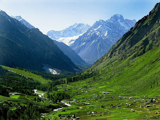
Azad Jammu & Kashmir is very rich in natural beauty. Its snow-covered peaks, dense forests, winding rivers, turbulent foaming streams, sweet-scented valleys, velvet green plateaus and climate varying from arctic to tropical, all work together to make it an excellent tourist resort. Valleys like Neelum, Jhelum, Leepa, Rawalakot, Banjosa, Samahni & Baghser unfold delightful scenic beauty and provide a feast of pleasure to a discerning tourist's eyes. Azad Kashmir is also blessed with a varied mountainous landscape ranging from low hills to high mountains 2000m to 6000m most suitable for soft to medium adventure tourism. The area provides excellent opportunities for rock climbing, trekking, mountaineering, summer camping and hikes. Moreover, blessed with a large number of river & streams Azad Kashmir offers great potential for white water sports, especially rafting, canoeing and kayaking.

Read more »

Thursday 20 October 2016

Province of Balochistan


Balochistan is The Largest Province of Pakistan by Area

The southwestern province of Pakistan is a hard place to make a living in or travel through. It’s a place of contradictions, at once Pakistan’s largest and most sparsely inhabited region, rich in natural resources but with an economically marginalised population. Mostly stony desert and sharp mountains, its importance lies in its strategic location, sitting astride the trade routes, both ancient and modern, to Iran, Afghanistan and the Arabian Sea and Balochistan is one of the four provinces of Pakistan, located in the southwestern region of the country. Its provincial capital and largest city is Quetta. Balochistan covers an area of 347,190 sq km. It is Pakistan's largest province by area, constituting 44% of Pakistan's total land mass. The province is bordered by Afghanistan to the north and north-west, Iran to the south-west, Punjab and Sindh, and Khyber Pakhtunkhwa and the Federally Administered Tribal Areas to the north-east. To the south lies the Arabian Sea. Balochistan is located on the south-eastern part of the Iranian plateau. It borders the geopolitical regions of the Middle East and Southwest Asia, Central Asia and South Asia. Balochistan lies at the mouth of the Strait of Hormuz and provides the shortest route from seaports to Central Asia. Its geographical location has placed the otherwise desolate region in the scope of competing global interests for all of recorded history.
The capital city Quetta is situated in a densely populated portion of the Sulaiman Mountains in the north-east of the province. It is situated in a river valley near the Bolan Pass, which has been used as the route of choice from coast to Central Asia, entering through Afghanistan's Kandahar region. The British and other historic empires have crossed the region to invade Afghanistan by this route.


Balochistan is rich in exhaustible and renewable resources. It is the second major supplier of natural gas in Pakistan. The province's renewable and human resource potential has not been systematically measured or exploited due to pressures from within and without Pakistan. Local inhabitants have elected to live in towns and have relied on sustainable water sources for thousands of years. Most of the province's inhabitants are Baloch people, Pashtuns and Brahuis, although there are smaller communities of Hazaras, Sindhis, Punjabis, and other settlers such as the Uzbeks, and Turkmens. The name Balochistan means, the land of the Baloch, in many regional languages. Regardless of the fact that largely underdeveloped, the provincial economy is dominated by natural resources, especially its natural gas fields, which supply the entire country. Gwadar Port also plays a significant role in the economic development of the province. Balochistan is noted for its unique culture, and extremely dry desert climate. The climate of the upper highlands is characterized by very cold winters and hot summers. In the lower highlands, winters vary from extremely cold in northern districts Ziarat, Quetta, Kalat, Muslim Baagh and Khanozai to milder conditions closer to the Makran coast. Winters are mild on the plains, with the temperature never falling below freezing point. Summers is hot and dry, especially in the arid zones of Chagai and Kharan districts. The plains are also very hot in summer, with temperatures reaching 50 °C.The record highest temperature, 53 °C, was recorded in Sibi on 26 May 2010, exceeding the previous record, 52 °C. Other hot areas includes, Turbat, and Dalbandin. The desert climate is characterised by hot and very arid conditions. Occasionally strong windstorms make these areas very inhospitablele. In August 1947 the Chief Commissioner's Province of Balochistan immediately became part of Pakistan, followed by the princely states of Makran, Kharan, Las Bela, and the Khanate of Kalat, who agreed to accede to Pakistan in March 1948. The Khan of Kalat agreed to join Pakistan under the condition that defence, currency, foreign relations, and finance would be controlled by the federal government, but that the province would remain otherwise autonomous. The four princely states together formed the Balochistan States Union in October 1952. The enclave of Gwadar was excluded from this as it was still part of the Sultanate of Oman.


In October 1955, formation of one unit resulted in the Balochistan States Union and the Chief Commissioner's Province of Balochistan being merged with all the remaining provinces and princely states in other parts of Pakistan to form the province of West Pakistan. The enclave of Gwadar was purchased from Oman in October 1958 and was also merged with West Pakistan. The province was officially dissolved in 1970 and the former Balochistan States Union, former Chief Commissioner's Province of Balochistan were brought together to form the new province of Balochistan. The government of Pakistan later decided to incorporate Gwadar in to Balochistan in 1977, thus expanding Balochistan province to its current form.
The economy of Balochistan is largely founded on the production of natural gas, coal and other minerals. Other important economic sectors include fisheries, mining, manufacturing industries, trade and other services being made by public and private sector organisations. Tourism remains limited but has increased due to the exotic appeal of the province. Limited farming in the east and fishing along the Arabian Sea coastline provides income and sustenance for the local population. Due to the tribal lifestyle of many Baloch and Brahui people, animal husbandry and trading bazaars found throughout the province are important. Balochistan has been called a, neglected province where a majority of the population lacks amenities. Since the mid-1970s the province's share of Pakistan's GDP has dropped from 4.9 to 3.7%, and as of 2007 it had the highest poverty rate and infant and maternal mortality rate, and the lowest literacy rate in the country, factors some allege have contributed to the insurgency. However, in 7th NFC awards Punjab province and Federal contributed to increase Baluchistan share more than it's entitled population based share. 


In Balochistan poverty is increasing. In 2001 to 2002 poverty incidence was at 48% and by 2005-2006 was at 50.9%. Though the province remains largely underdeveloped, several major development projects, including the construction of a new deep sea port at the strategically important town of Gwadar, are under way in Balochistan. The port is expected to be the hub of an energy and trade corridor to and from China and the Central Asian republics. Mirani Dam on the Dasht River, 50km west of Turbat in the Makran Division, is being built to provide water to expand agricultural land use by 35,000 sq km  where it would otherwise be unattainable. In the south east is an oil refinery owned by Byco International Incorporated, which is capable of processing 120,000 barrels of oil per day. A power station is situated adjacent to the refinery. Several cement plants and a marble factory are also located there. One of the world's largest ship breaking yards is situated on the coast. Balochistan's share of Pakistan's national income has historically ranged between 3.7% to 4.9%. Since 1972, Balochistan's gross income has grown in size by 2.7 times. Outside Quetta, resource extraction infrastructure of the province is gradually developing but still lags far behind other parts of Pakistan. In common with the other provinces of Pakistan, Balochistan has a parliamentary form of government. The ceremonial head of the province is the Governor, who is nominated by the President of Pakistan on the advice of the provincial Chief Minister. The Chief Minister, the province's chief executive, is normally the leader of the largest political party or alliance of parties in the provincial assembly. The unicameral Provincial Assembly of Balochistan comprises 65 seats of which 11 are dedicated to women and 3 reserved for non-Muslims. The judicial branch of government is performed by the Balochistan High Court, which is based in Quetta and headed by a Chief Justice. Besides dominant Pakistan wide political parties, such as the Pakistan Muslim League (N) and the Pakistan Peoples Party, Balochistan nationalist parties, such as the National Party and the Balochistan National Party, have been prominent in the province and for administrative purposes, the province is divided into six Divisions, Kalat, Makran, Nasirabad, Quetta, Sibi and Zhob. This divisional level was abolished in 2000, but restored after the 2008 election. Each Division has an appointed Commissioner. 


The six Divisions are further subdivided into 32 districts. Balochistan's population density is very low due to the mountainous terrain and scarcity of water. In March 2012, preliminary census figures showed that the population of Balochistan had reached 13,162,222, not including the districts of Khuzdar, Kech and Panjgur, 139.3% increase from 5,501,164 in 1998, representing 6.85% of Pakistan's total population. This was the most important increase in population by any province of Pakistan during that time period. Official estimates of Balochistan's population grew from approximately 7.45 million in 2003 to 7.8 million in 2005. A number of tribes constitute to ensure that people of Balochistan. Three major tribes are Baloch, Baloch & Brahvi,  and Pashtoon. The Balochi speaking tribes include Rind, Lashar, Marri, Jamot, Ahmedzai, Bugti Domki, Magsi, Kenazai, Khosa, Rakhashani, Dashti, Umrani, Nosherwani, Gichki, Buledi, Notazai, Sanjarani, Meerwani, Zahrozai, langove, kenazai and Khidai. Each tribe is further sub-divided into numerous branches. The tribal chief is called Sardar while head of sub-tribe is known as Malik, Takari or Mir. Sardars and Maliks are members of district and other local Jirgas according to their status. The Baloch, believed to have originally come from Arabia or Asia minor, can be split into to two branches: the Sulemani and Mekrani as distinct from the Brahvis who mostly concentrate in central Balochistan. Among the eighteen major Baloch tribes, Bugtis and Marris are the main ones who are settled in the buttresses of the Sulemania. The Talpur of Sind aIso claims their Baloch origin. Brahvi speaking tribe include Raisani, Shahwani, Sumulani, Sarparrah, Bangulzai, Mohammad Shahi, Lehri, Bezenjo, Mohammad Hasni, Zehri , Sarparrah, Mengal, Kurd,Sasoli, Satakzai, Lango, Rodeni, Kalmati, Jattak, Yagazehi and Qambarani , most of these tribes are bi-lingual and are quite fluent both in the Balochi and Brahvi Languages. Pashtoon tribes include Kakar, Ghilzai Tareen, Mandokhel, Sherani, Luni, Kasi and Achakzai.


Balochistan, despite its scarce population, has an uncommon racial and tribal diversity. Most of the people in the cities and towns understand and speak more than two languages. In addition to Balochi, Pashtoo and Brahvi, the majority of the population understands and speaks Urdu, the national language. In Kachhi and Sibi districts, people speak Saraiki and Sindhi. Quetta city, the confluence point of all linguistic groups accommodates not only Urdu, Balochi, Pashtoo, Brahvi and Sindhi speaking people but Darri and Persian speaking ones as well. Dehwar tribe of Sarawan sub-division in Kalat, also speaks a language derived from Persian.
Cultural landscape of Balochistan portrays various ethnic groups. Though people speak different languages, there is a similarity in their literature, beliefs, moral order and customs. The cementing factor is religion which provides a base for unity and common social order. Brahvi, Balochi and Pashtoon tribes are known for their hospitality. Guest is accorded, is held in high esteem and considered a blessing from God. Better off people even slaughter sheep or goat for their guest. Sometimes, it so happens that where there are more houses, the guest is deemed to be the guest of the whole village. This open handedness is the loving feature of the tribal people and is not as deep in the city or town dwellers. Another adorable feature of Balochistan culture is faithfulness and sincerity in all relationships. There is not any place or respect for unfaithful people in prevalent moral order. If fidelity is reciprocated with disloyalty or betrayal it is never forgotten. Marriages are solemnized in presence of Mullah, a religious teacher, and witnesses. Life partners are generally selected within the family, constituting all close relatives, or tribe. Except a negligible fraction of love marriages, all marriages are classified. Divorce rate is quite low.


A lot of marriage rituals are celebrated in separate tribes. In some tribes, takings of, Valver, a sum of money paid by the groom to his to be wife’s family, also exist. But this custom is now gradually dying out since it has given rise to many social problems. The birth of a male child is taken as a source of p ride since he is though t to be the defender of this family and tribe.
The mode of dress among the Balochi, Pashtoon and Brahvi tribes is very similar having a couple of minor dissimilarities. Turban is the common headwear of the men. Wide loose shalwar, a bit similar to loose trousers, and knee-long shirts are worn by all. The dress of the woman consists of the typical shirt having a capacious pocket in front. The shirt normally has embroidery work with embedded small round mirror pieces. Big, Dopatta or Chaddar, a long rectangular piece of cloth cascading down the shoulders and used to cover head, is used by the women. There are religious and social festivals celebrated by the people of Balochistan. Two major religious festivals are Eid-ul-Azha and Eid-ul-Fiter. On these festivals people adorn their houses, wear new dresses, cook special dishes and see each other. Eid-Meladun-Nabi is another sacred festival. It is observed of the Holy Prophet’s birthday. Numerous colorful social festivals are also a source of jubilation. Sibi festival that traces its roots to Mehergar, an archeological site of ancient human civilization, attracts people from across the country. It is attended by ordinary folks, ministers and other government officials. Folk music performance, cultural dances, handicrafts stalls, cattle shows and a number of other amusing activities present a perfect riot of color. Buzkashi is a peculiar festival showing valour of Balochistan people. It is celebrated on horse-back by two teams that use their skills to snatch a goat from the each other.


Read more »

Tuesday 4 October 2016

Province of Khyber Pakhtunkhwa


Khyber Pakhtunkhwa is Previously Known as NWFP

The Pakhtoon Khwah is the land of Pakhtoon or Pathans as called by the English. This is the north western province of Pakistan and Khyber Pakhtunkhwa is one of the four provinces of Pakistan, situated in the northwestern region of the country. It was formerly known as North West Frontier Province and commonly called Sarhad, which in Urdu means,frontier. Its provincial capital and largest city is Peshawar, followed by Mardan. It shares a border with the Federally Administered Tribal Areas to the west, Gilgit Baltistan to the northeast; Azad Kashmir, Islamabad and Punjab to the east and southeast. Khyber Pakhtunkhwa does not share a border with Balochistan which lies to its southwest. Khyber Pakhtunkhwa also shares an international border with Afghanistan, connected through the Khyber Pass. Khyber Pakhtunkhwa means, Khyber side of the land of Pakhtuns, while only the word Pakhtunkhwa means, Land of Pakhtuns and according to some scholars it means, Pakhtun culture and society. When the British established it as a province, they called it, North West Frontier Province, due to its relative location being in north west of their Indian Empire. After independence of Pakistan, Pakistan continued with this name but a Pakhtun nationalist party, Awami National Party demanded that the province name be replaced by, Pakhtunkhwa. Their logic behind that demand was that Punjabi people, Sindhi people and Balochi people have their provinces named after their ethnicities but that is not the case for the Pashtun people.
It is also the site of the ancient kingdom of Gandhara, the ruins of its capital, Pushkalavati, modern day Charsadda, and the most prominent center of learning in the Peshawar Valley, Takht-i-Bahi. It has been subject to the suzerainty of the Persians, Greeks, Mauryans, Kushans, Shahis, Ghaznavids, Mughals, Sikhs, and British Empire throughout its long history. 


Khyber Pakhtunkhwa is the third largest province of Pakistan by the size of both population and economy though it is geographically the smallest of four. It comprises 10.5% of Pakistan's economy, and is host to 11.9% of Pakistan's total population, with the majority of the province's inhabitants being Pashtuns, Hazarewal, Chitrali, and Kohistanis. After the independence of Pakistan in 1947, Afghanistan was the only member of the United Nations to vote against Pakistan's accession to the UN because of Kabul's claim to the Pashtun territories on the Pakistani side of the Durand Line. Afghanistan's Loya Jirga of 1949 declared the Durand line invalid, which led to border tensions with Pakistan, and decades of mistrust between the two states. Afghan governments have also periodically refused to recognize Pakistan's inheritance of British treaties regarding the region. During the 1950s, Afghanistan supported the secessionist Pushtunistan movement, although it failed to gain substantial support amongst the
population of the North West Frontier Province. During the Soviet occupation of Afghanistan 1979 to 1989, the NWFP served as a major supply base for the Afghan Mujahideen who fought the Soviet Union during the 1980s. As a result of the Soviet invasion, over five million Afghan refugees poured into Pakistan, mostly deciding to reside in the NWFP, as of 2007, nearly 3 million remained. The province remained strongly influenced by events in Afghanistan thereafter. The 1989 to 1992 civil war in Afghanistan following the withdrawal of Soviet forces led to the rise of the Afghan Taliban, which had emerged in the border region between Afghanistan, Balochistan, and FATA as a formidable political force. Khyber Pakhtunkhwa sites primarily on the Iranian plateau and comprises the junction where the slopes of the Hindu Kush mountains on the Eurasian plate give way to the Indus-watered hills approaching South Asia. This situation has led to seismic activity in the past. The famous Khyber Pass links the province to Afghanistan, while the Kohalla bridge in circle Bakote Abbottabad is a major crossing point over the Jhelum River in the east.


Khyber Pakhtunkhwa has the third largest provincial economy in Pakistan. Khyber Pakhtunkhwa's share of Pakistan's GDP has historically comprised 10.5%, although the province accounts for 11.9% of Pakistan's total population. The part of the economy that Khyber Pakhtunkhwa dominates is forestry, where its share has consistently ranged from a low of 34.9% to a high of 81%, giving an average of 61.56%. Currently, Khyber Pakhtunkhwa accounts for 10% of Pakistan's GDP, 20% of Pakistan's mining output and, since 1972, it has seen its economy grow up in size by 3.6 times. After suffering for decades due to the fallout from the Soviet invasion of Afghanistan, today they are again being targeted for a different situation of terrorism. Agriculture remains important and the main cash crops include wheat, maize, tobacco, in Swabi, rice, sugar beets, as well as fruits are produced in the province. Some manufacturing and high tech investments in Peshawar has helped improve job prospects for many locals, while trade in the province involves nearly every product. The bazaars in the province are renowned throughout Pakistan. Unemployment has been reduced due to the establishment of industrial zones.Workshops throughout the province support the manufacture of small arms and weapons. The province makes up at least 78% of the marble production in Pakistan. Geographically the province could be divided into two zones, the northern one extending from the ranges of the Hindu Kush to the borders of Peshawar basin and the southern one extending from Peshawar to the Derajat basin. The northern zone is cold and snowy in winters with heavy rainfall and pleasant summers with the exception of Peshawar basin, which is hot in summer and cold in winter. It has moderate rainfall. The southern zone is arid with hot summers and relatively cold winters and scanty rainfall. The major rivers that criss cross the province are the Kabul, Swat, Chitral, Kunar, Siran, Panjkora, Bara, Kurram, Dor, Haroo, Gomal and Zhob. Its snow capped peaks and lush green valleys of uncommon beauty have enormous potential for tourism.


Nature has gifted Khyber Pakhtunkhwa with rich cultural and tourism friendly environment. It has the potential of becoming a big tourist attraction in the world, due to its scenic beauty, geographical location, climate and natural resources. Khyber Pakhtunkhwa is exceptionally rich in terms of multitudes of tourist attraction. The essence of this attraction is visible from the remarkable natural picturesque comprising beautiful rivers, splendid water falls, spell-bound lakes mostly in the mountainous region and green valleys in most parts of the province. Due to its geographical location, Khyber Pukhtunkhwa has had been a confluence of different civilizations which flourished and vanished with the passage of time. The quasi contiguity of the province, with the Central Asian states and with xiangiang province of China attracted many migrants, businessmen, warriors and fortune seekers in different ages for settlement. Hindko and Pashto folk music are popular in Pakhtunkhwa and has a rich tradition going back hundreds of years. The main instruments are the rubab, mangey and harmonium. Khowar folk music is well known in Chitral and northern Swat. Tunes of Khowar music are very different from those of Pashto and the main instrument is the Chitrali sitar. A form of band music composed of clarinets, surnai, and drums is popular in Chitral. It is played at polo matches and dances. 
The same form of band music is played in the neighbouring Northern Areas and The interaction among different races and their co-existence led to a rich cultural heritage. The glimpses of such heritage are evident from the Ghandhara archaeological sites at Gur Khattree Peshawar, Takh-i- Bahi, Mardan, Seri Behlol, Mardan, Shabaz Gari, Mardan, Nimo Gram Buddhist Stupa, Swat, and collection of Ghandhara art preserved at Swat Museum, Chakdara museum, Dir Lower and Peshawar museum. The dominant language of the Province, Pashto, belongs to the Irani branch of the Aryan family of languages. It consists of two main dialects. Pakhto and Pashto. Pakhto is the hard or north-eastern version spoken in Bajaur, Swat and Buner, by the Yusufzai, Bangash, Orakzai, Afridi and Momand tribes. Pashto is the soft or south western version spoken by the Khattaks, Wazirs, Marwats and other tribes in the south. The earliest Pashto works were composed in the Yusufzai dialect which is reviewed classical. It is the purest and the clearest form of the language. Pakhto or Pashto is the main language, spoken and understood mainly in the central districts. Hindko, a Punjabi dialect, is in majority in Hazara Division and also in the central old city areas of Nowshera, Kohat and Peshawar cities. Saraiki, a Punjabi dialect, is in the majority in the southern districts of DI Khan and Tank Khowar, by people in the north especially in majority in district Chitral. Standard Punjabi, minority living in major cities and all cantonment areas. Kohistani, majority in Kohistan district and the north half of Swat District. Gojr minority throughout northern half of the province. Dari, Hazaragi, Farsi, Tajik and varieties of Persian spoken by Afghan refugees. Other languages include, Kashmiri, Shina, Romani, Burushaski, Wakhi, Balti, Balochi,  Brahui, Sindhi and English, official and used in tourism, only Urdu and English are found as written languages in the city. English, the official language of Pakistan, is primarily used for official and literary purposes. 


The climate of Khyber Pakhtunkhwa varies immensely for a region of its size, encompassing most of the various climate types found in Pakistan. The province stretching southwards from the Baroghil Pass in the Hindu Kush covers almost six degrees of latitude, it is mainly a mountainous region. Dera Ismail Khan is one of the hottest places in South Asia while in the mountains to the north the weather is mild in the summer and intensely cold in the winter. The air is usually very dry; consequently, the daily and annual range of temperature is quite large. Rainfall also varies widely. Although large parts of Khyber Pakhtunkhwa are typically dry, the province also contains the wettest parts of Pakistan in its eastern fringe specially in the monsoon season from mid June to mid September and In South, in the districts of Dir, Swat and Hazara Division, the climate becomes more typical of the Indian subcontinent, although a considerable proportion of the annual precipitation still comes from frontal cloud bands during the winter months. The combination of a short but powerful summer monsoon with frequent winter cloud bands gives a bimodal rainfall regime in central parts of Khyber Pakhtunkhwa.


Read more »

Saturday 1 October 2016

Province of Sindh


Sindh is Well Known as Land of Mehran

Sindh is named for the great Indus River that carves its way through the plains of the province, bringing it to life and Sindh is one of the four provinces of Pakistan and situated in the southeast of the country. Historically home to the Sindhi people, it is equally locally known as the Mehran. It was previously known as Sind until the 1956. Sindh is the third largest province of Pakistan by area, and second largest province by population after Punjab. Sindh is bordered by Balochistan province to the west, and Punjab province to the north. Sindh also borders the Indian states of Gujarat and Rajasthan to the east, and the Arabian Sea to the south. Sindhi's landscape consists mostly of alluvial plains flanking the Indus River, the Thar desert in the eastern portion of the province closest to the border with India, and the Kirthar mountains in the western part of Sindh. The word Sindh is derived from the Sanskrit language and is adapted from the Sanskrit term Sindhu which literally means, river, hence a reference to the Indus River. Spelling of its official name as Sind was discontinued in 2013 by an amendment passed in the Sindh Assembly. On August 14 of 1947 Pakistan gained independence from colonial British colonial rule. The province Sindh attained self rule, the first time since the defeat of Sindhi Talpur Amirs in the battle of Miani on February 17, 1843. The major challenge faced by the Government of Sindh was the settlement of Muslim refugees. Nearly 7 million Muslims from India migrated to Pakistan while nearly equal number of Hindus and Sikhs from Pakistan migrated to India. Muslim refugees known as Muhajirs from India settled in most urban areas of Sindh. Sindh at the time of partition was home to a large number of Hindus who accounted for 27% of the total population of the province. They were more concentrated in the urban centres of the province and had a strong hold on the province's economy and business. 


Although the relations between the local Muslims and Hindus were good but with the arrival of Muslim refugees in the urban centres of the province, Hindus began to feel unsafe. This along with unstable future in a Muslim country and better opportunities in India made a large number of Sindhi Hindus to abandon the province. Sindh did not witness any massive level genocide as other parts of the Subcontinent, especially Punjab region, did, comparatively there were few incidents of riots in Karachi and Hyderabad but over all situation remained peaceful mainly due to the efforts of the Chief Minister of Sindh Mr. Ayub Khuhro. At present there are relatively 2.9 million Hindus in Sindh forming 7.5% of the total population of the province. Sindhi Hindus in Pakistan are mainly into small to medium sized businesses. They are mostly traders, retailer and wholesalers, builders as well as into the fields of medical, engineering, law and financial services. However, the scheduled caste Hindus are in a poorer state with most of them as bonded labour in the rural areas of the province. Most of the Muslim refugees are resolved in urban areas of Sindh especially in Karachi and Hyderabad. Since Pakistan's Independence in 1947, Sindh has been the destination of a continuous stream of migration from South Asian countries like Bangladesh, Burma, and Afghanistan as well as Pashtun and Punjabi immigrants from the North West Frontier Province and the Punjab Province of Pakistan to Karachi. This is explained by the fact that Karachi is the economic magnet of Pakistan attracting people from all over Pakistan. Numerous native Sindhis resent this influx. Nonetheless, traditional Sindhi families remain prominent in Pakistani politics, especially Bhutto, Zardari and Soomro dynasties. Muhammad Ali Jinnah, the founder of Pakistan, was from Karachi, Sindh but was a Gujarati. 


The Sindh assembly was the former British Indian legislature to pass the resolution in favour of Pakistan. G. M. Syed, an influential Sindhi activist, revolutionary and Sufi and one of the important leaders to the forefront of the provincial autonomy movement joined the Muslim League in 1938 and presented the Pakistan resolution in the Sindh Assembly. Sindh is in the western corner of South Asia, bordering the Iranian plateau in the west. Geographically it is the third largest province of Pakistan, stretching from 579km from north to south and 442km, extreme, or 281km, average, from east to west, with an area of 140,915 square km of Pakistani territory. Sindh is bounded by the Thar Desert to the east, the Kirthar mountains to the west, and the Arabian Sea in the south. In the centre is a fertile plain around the Indus River. Sindh has the second largest economy in Pakistan. Its GDP per capita was $1,400 in 2010 which is 50% more than the rest of the nation or 35% more than the national average. Historically. Sindh's contribution to Pakistan's GDP has been between 30% to 32.7%. Its share of the service sector has ranged from 21% to 27.8% and in the agriculture sector from 21.4% to 27.7%. Performance wise, its best sector is the manufacturing sector, where its share has ranged from 36.7% to 46.5%. Since 1972, Sindh's GDP has increased by 3.6 times. Endowed with coastal access, Sindh is an important centre of economic activity in Pakistan and has a highly diversified economy ranging from heavy industry and finance centred in and around Karachi to a substantial agricultural base along the Indus. Manufacturing includes machine products, cement, plastics, and other goods. Sindh is Pakistan's most natural gas producing province. Agriculture is extremely important for Sindh with cotton, rice, wheat, sugar cane, dates, bananas, and mangoes as the most important crops. Sindh is the richest province of Pakistan in natural resources of gas, petrol, and coal. Sindh's capital, Karachi hosts the headquarters of several national banks. Sindh is home to a large portion of Pakistan's industrial sector as well. Sindh contains two of Pakistan's commercial seaports Port Bin Qasim and the port of Karachi. 


The remainder of Sindh has an agriculture based economy, and produces fruit and vegetables for consumption other parts of the country. Sindh is also the centre of Pakistan's pharmaceutical industry. Sindh is known for its distinct culture, which is strongly influenced by Sufism. Several important Sufi shrines are located throughout the province which attracts millions of annual devotees and Sindhi culture is very popular all over the world for its arts, crafts and heritage as well. Sindh also has Pakistan's highest percentage of Hindu residents. Sindh's capital, Karachi, is Pakistan's most ethnically diverse city, with Muhajirs, or descendants of those who migrated to Pakistan from India in 1947, making up the majority of the population. The city has seen ethnic tensions boil over into violence on several occasions. Sindh is home to two UNESCO world heritage sites - the Historical Monuments at Makli, and the Archaeological Ruins at Moenjodaro. Sindh lies in a tropical to subtropical region; it is hot in the summer and mild to warm in winter. Temperatures frequently rise above 46 °C between May and August, and the average minimum temperature of 2 °C occurs during December and January in the northern and higher elevated regions. The annual rainfall averages about seven inches, falling mainly during July and August. The southwest monsoon wind begins in mid February and continues until the end of September, whereas the cool northerly wind blows during the winter months from October to January. Sindh lies between the two monsoons the southwest monsoon from the Indian Ocean and the northeast or retreating monsoon, deflected towards it by the Himalayan mountains and escapes the influence of both. The region's scarcity of rainfall is compensated by the inundation of the Indus twice a year, caused by the spring and summer melting of Himalayan snow and by rainfall in the monsoon season.


Sindh is divided into three climatic regions. Siro, the upper region, centred on Jacobabad, Wicholo, the middle region, centred on Hyderabad, and Lar, the lower region, centred on Karachi. Thermal equator passes through upper Sindh, where the air is generally very dry. Central Sindh's temperatures are usually lower than those of upper Sindh but higher than those of lower Sindh. Dry hot days and cool nights are common during the summer. Central Sindh's maximum temperature typically reaches 43 to 44 °C. Lower Sindh has a damper and humid maritime climate affected by the southwestern winds in summer and northeastern winds in winter, with lower rainfall than central Sindh. Lower Sindh's maximum temperature reaches about 35 to 38 °C. In the Kirthar range at 1,800m and higher at Gorakh Hill and other peaks in Dadu district, temperatures near freezing have been recorded and brief snowfall is received in the winters. The Provincial Assembly of Sindh is a unicameral and consists of 168 seats, of which 5% are reserved for non muslims and 17% for women. The provincial capital of Sindh is Karachi. The provincial government is headed by Chief Minister who is directly elected by the popular and landslide votes; the Governor serves as a ceremonial representative nominated and appointed by the President of Pakistan. Most of the influential Sindhi tribes in the province participate in Pakistan's politics. Sindhi is the main language of the province and other languages include Saraiki, Dhatki, Kashmiri, Gujarati, Memoni, Dari, Kutchi, Khowar, Shina, Kashmiri, Bengali , Lari, Brahui and Parkari Koli, sometimes called just Parkari, a language only spoken by 250,000 natives of Sindh according to 1995 estimates. Tourist sites include the ruins of Mohenjo-daro near the city of Larkana, Runi Kot, Kot Deji, the Jain temples of Nangar Parker and the historic temple of Sadhu Bela, Sukkur. Islamic architecture is quite prominent in the province; its numerous mausoleums include the ancient Shahbaz Qalander mausoleum and there are a lot of other tourist attractions, that attracted to national and foreign tourists, in province of Sindh.


Read more »

Monday 26 September 2016

Pakistani Province of Punjab


Punjab is The Largest Province by Population in Pakistan

Punjab is Pakistan's most populous province with an estimated population of 101,391,000 as of 2015 and Punjab has an area of 205,344 sq km and it is the 2nd largest province after Balochistan and is located at the northwestern edge of the geologic Indian plate in South Asia. The province is bordered by Azad Kashmir to the north-east, the Indian states of Punjab and Rajasthan to the east, the province of Sindh to the south, the province of Balochistan to the southwest, the province of Khyber Pakhtunkhwa to the west, and the Islamabad Capital Territory to the north. The capital and largest city is Lahore which was the historical capital of India during the Moghul times. Other important cities of Punjab include Gujrat, Multan, Faisalabad, Sheikhupura, Sialkot, Gujranwala, Jhelum and Rawalpindi. Punjab is a mainly a fertile region along the river valleys. While in the southern belt deserts of Cholistan is a bare land. The landscape is amongst the most heavily irrigated on earth and canals can be found throughout the province. Weather extremes are notable from the hot and barren south to the cool hills of the north. The foothills of the Himalayas are found in the extreme north as well.
The Lahore, capital of Punjab is a cultural centre of Pakistan where the country's cinema industry, and much of its fashion industry, is based. Punjab literally means the land of 5 rivers term refers to the 5 rivers flowing thru the region. Due to its rivers of Punjab is the most fertile and most populated province of Pakistan. People speak Punjabi here and have many colorful traditions and culture of Punjab is very rich. Punjab is considered most developed, populous, and prosperous province of Pakistan having about 60% of the country's total population being placed in it.


In 1947, the Punjab province of British India was divided along religious lines into West Punjab and East Punjab. Western Punjab was equated into the new country of Pakistan, while East Punjab became a part of modern-day India. This resulted in massive rioting as both sides committed atrocities against fleeing refugees. The part of the Punjab now in Pakistan once formed a major region of British Punjab, and was host to a large minority population of Punjabi Sikhs and Hindus up to 1947 apart from the Muslim majority. Migration between India and Pakistan was continuously before independence. By the 1900s Western Punjab was predominantly Muslim and supported the Muslim League and the Pakistan Movement. After independence, the minority Hindus and Sikhs migrated to India while Muslim refugees from India settled in the Western Punjab and across Pakistan. Since the 1950s, Punjab industrialised rapidly. Modern factories were established in Lahore, Sargodha, Multan, Gujrat, Gujranwala, Sialkot and Wah. In the 1960s, the new city of Islamabad north of Rawalpindi.
 Agriculture remains the largest sector of Punjab's economy. The province is the breadbasket of the country as well as home to the largest ethnic group in Pakistan, the Punjabis. Unlike neighbouring India, there was not any large-scale redistribution of agricultural land. As a result, most rural areas are characterized by a small set of feudalistic land-owning families. In the 1950s, there was tension between the eastern and western halves of Pakistan. To address the situation, a different formula resulted in the abolition of the province status for Punjab in 1955. It was merged into a single province of West Pakistan. In 1972, after East Pakistan seceded and became Bangladesh, Punjab again became a province. Punjab witnessed major battles between the armies of India and Pakistan in the wars of 1965 and 1971. Since the 1990s, Punjab hosted several key sites of Pakistan's nuclear program such as Kahuta. It also hosts major military bases such as at Sargodha and Rawalpindi. The peace process between India and Pakistan, which began in earnest in 2004, has helped pacify the situation. Trade and people-to-people contacts through the Wagah border are currently starting to become common. Indian Sikh pilgrims visit holy sites such as Nankana Sahib. Starting in the 1980s, large numbers of Punjabis migrated to the Middle East. Britain, Spain, Canada and the United States for economic opportunities, forming the large Punjabi diaspora. Business and cultural ties between the United States and Punjab are growing.


Punjab is Pakistan's most industrialised province with the industrial sector making up 24% of the province's gross domestic product and its manufacturing industries produce textiles, sports goods, heavy machinery, electrical appliances, surgical instruments, vehicles, auto parts, metals, sugar mill plants, aircraft, cement, agricultural machinery, bicycles and rickshaws, floor coverings, and processed foods. In 2003, the province manufactured 90% of the paper and paper boards, 71% of the fertilizers, 69% of the sugar and 40% of the cement of Pakistan.
Punjab gets the largest economy in Pakistan, contributing most to the national GDP. The province's economy has quadrupled since 1972. its share of Pakistan's GDP was 54.7% in 2000 and 59% as of 2010. It is particularly dominant in the service and agriculture sectors of Pakistan's economy. With its contribution ranging from 52.1% to 64.5% in the Service Sector and 56.1% to 61.5% in the agriculture sector. It is also a major manpower contributor because it has the largest pool of professionals and highly skilled manpower in Pakistan. It is also dominant in the manufacturing sector, though the dominance is not as huge, with historical contributions ranging from a low of 44% to a high of 52.6%. In 2007, Punjab achieved a growth rate of 7.8% and during the period 2002-03 to 2007-08, its economy grew at a rate of between 7% to 8% per year. and during 2008-09 grew at 6% against the total GDP growth of Pakistan at 4%. Punjab is known in Pakistan for its relative prosperity, and has the lowest rate of poverty amongst all Pakistani provinces. A clear divide is found between the northern and southern portions of the province with poverty rates in prosperous northern Punjab amongst the lowest in Pakistan, while some in south Punjab are among the most impoverished. Punjab is among South Asia's most urbanized regions with approximately 40% of people living in urban areas. Its human development index rankings are high relative to the rest of Pakistan. Punjab is well known in Pakistan for its relatively liberal social attitudes. The province has been greatly influenced by Sufism, with numerous Sufi shrines spread across Punjab which attract millions of devotees annually. The founder of the Sikh faith, Guru Nanak, was born in the Punjab town of Nankana Sahib near Lahore. Punjab is equally the site of the Katasraj Temple, which features prominently in Hindu mythology. Several UNESCO World Heritage Sites are located in Punjab, including the Shalimar Gardens, Lahore Fort, the archeological excavations at Taxila, and the Rohtas Fort.


Punjab's landscape consists most of fertile alluvial plains of the Indus River and its four major tributaries in Pakistan, the Jhelum, Chenab, Ravi, and Sutlej rivers which traverse Punjab north to south - the fifth of the five waters of Punjab, the Beas River, lies exclusively in the Indian state of Punjab. The landscape is amongst the most heavily irrigated on earth and canals can be found throughout the province. Punjab also includes several mountainous regions, including the Sulaiman Mountains in the southwest part of the province, the Margalla Hills in the north near Islamabad, and the Salt Range which divides the most northerly portion of Punjab, the Pothohar Plateau, from the rest of the province. Sparse deserts can be found in southern Punjab near the border with Rajasthan and near the Sulaiman Range. Punjab also contains part of the Thal and Cholistan deserts. In the north, Punjab's elevation reaches 2,291 metres near the hill station of Murree, which is surrounded by lush and dense forest. Most areas in Punjab experience extreme weather in foggy winters, often accompanied by rain. By mid-February the temperature starts to rise; springtime weather continues until mid-April, when the summer heat sets in.


The onset of the southwest monsoon is anticipated to reach Punjab by May. But since the early 1970s the weather pattern has been irregular. The spring monsoon has either skipped over the area or has caused it to rain so hard that floods have resulted. June and July are oppressively hot. Although official estimates rarely place the temperature above 46 °C, newspaper sources claim that it reaches 51 °C and regularly carry reports about people who have succumbed to the heat. Heat records were broken in Multan in June 1993, when the mercury was reported to have risen to 54 °C. In August the oppressive heat is punctuated by the rainy season, referred to as barsat, which brings relief to its wake. The hardest part of the summer is then over, but cooler weather does not come until late October. Recently the province experienced one of the coldest winters in the last 70 years. Punjab's regional temperature ranges from −2° to 45 °C, but can reach 50 °C,122 °F, in summer and can touch down to −10 °C in Winter. Climatically. Punjab has three major seasons. Hot weather, April to June, when the temperature rises as high as 110 °F. Rainy seasons, July to September. Average rainfall annual ranges between 96cm sub-mountain regions and 46cm in the Plains. Cooler, Foggy and mild weather, October to March. temperature goes down as low as 40 °F. weather extremes are notable from the hot and barren south to the cool hills of the north. The foothills of the Himalayas are found in the extreme north as well, and features a much cooler and wetter climate, with snowfall common at higher altitudes.


The major and native language spoken in the Punjab is Punjabi, which is written in a Shahmukhi script in Pakistan and Punjabis comprise the largest ethnic group in country. Punjabi is the provincial language of Punjab. There is not a single district in the province where the Punjabi language is mother-tongue of less than 89% of the population. The language does not receive any official recognition in the Constitution of Pakistan at the national level. Punjabi dialects spoken in the province include Majhi, Standard, Saraiki and Hindko. Punjabi Saraiki is mostly spoken in southern Punjab, and Pashto, spoken in some parts of north west Punjab, especially in Attock district and Mianwali district near Khyber Pakhtunkhwa province.
The Government of Punjab is a provincial government in the federal structure of Pakistan, is based in Lahore, the capital of the Punjab province. The Chief Minister of Punjab is elected by the Provincial Assembly of the Punjab to serve as the head of the provincial government of Punjab, Pakistan. The current Chief Minister is Shahbaz Sharif, who became the Chief Minister of Punjab is being restored after Governor's rule starting from 25 February 2009 to 30 March 2009. Thereafter got re-elected as a result of 11 May 2013 elections. The Provincial Assembly of the Punjab is a unicameral legislature of elected representatives of the province of Punjab, which is located in Lahore in eastern Pakistan. The Assembly was established pursuant to Article 106 of the Constitution of Pakistan as having a total of 371 seats, with 66 seats reserved for women and eight reserved for non-Muslims. There are 48 departments in the Punjab government. Each department is headed by a Provincial Minister, politician and a Provincial Secretary, a civil servant of usually BPS-20 or BPS-21. All Ministers report to the Chief Minister, who is the Chief Executive. All Secretaries report to the Chief Secretary of Punjab, who is usually a BPS-22 Civil Servant. Chief Secretary in turn reports to the Chief Minister. In addition to these departments, there are several Autonomous Bodies and Attached departments that report directly to either the secretaries or the Chief Secretary.


Read more »

Sunday 19 June 2016

Huawei Y3II Smartphone

Huawei New Yii3 Smartphone

Dimensions
134.2 x 66.7 x 9.9 mm  
Weight
150 g  
Battery
2100 mAh  
OS
Android OS, v5.1 (Lollipop) 
Memory
8GB built-in, 1GB RAM, microSD card (supports up to 32GB) (dedicated slot) 
Processor
3G-Model 1.3 GHz Quad-Core Cortex-A7, Mediatek MT6582MM
GPU: Mali-400MP2
4G-Model 1.0 GHz Quad-Core Cortex-A53, Mediatek MT6735M
GPU: Mali-T720MP2  
Connectivity
Bluetooth v4.0 with A2DP, LE, USB (microUSB v2.0), WLAN (Wi-Fi 802.11 b/g/n, hotspot), GPRS, EDGE, 3G HSPA, 4G LTE  
Display Size
4.5 inches, 480 x 854 pixels (~218 ppi pixel density)
Sensors: Accelerometer, proximity  
Display Colour
Capacitive touchscreen, 16M colors, Multitouch, Emotion UI 3.1 Lite  
Operating
Frequency / Band
SIM1: GSM 850 / 900 / 1800 / 1900
SIM2: GSM 850 / 900 / 1800 / 1900  
3G Band
HSDPA 850 / 900 / 1900 / 2100  
4G Band
LTE band 1(2100), 3(1800), 7(2600), 8(900), 20(800)  
Browser
HTML5  
Colors
Obsidian Black, Arctic White, Sand Gold, Rose Pink, Sky Blue  
Entertainment
FM radio, 3.5mm Jack, MP3/WAV/eAAC+ player, MP4/H.264 player, YouTube, Google Talk, Google Search, Maps, Gmail, Games  
Camera
5 MP, autofocus, Dual-LED flash, Video, 2ndry 2 MP  
Other Features
GPS + A-GPS support, Document viewer, Dual SIM + Micro-SIM, dual stand-by), Photo/video editor  
Ring Tones
Downloadable, Polyphonic, WAV, MP3  
Messaging
SMS(threaded view), MMS, Email, Push Email, IM

Read more »

Contact

Name

Email *

Message *

NADRA

NATIONAL DATABASE & REGISTRATION AUTHORITY

NADRA is one of the leading System Integrators in the global identification sector and boasts extensive experience in designing, implementing and operating solutions for corporate and public sector clients. NADRA offers its clients a portfolio of customizable solutions for identification, e-governance and secure documents. NADRA has successfully implemented the Multi-Biometric National Identity Card & Multi-Biometric e-Passport solutions for Pakistan, Passport Issuing System forKenya, Bangladesh High Security Driver’s License, and Civil Registration Management System for Sudan amongst other projects. National Database & Registration Authority (NADRA) has gained international recognition for its success in providing solutions for identification, e-governance and secure documents that deliver multi-pronged goals of mitigating identity theft, safe-guarding the interests of our clients, and facilitating the public. In-depth Research and Development efforts have enabled NADRA to become the trailblazer in the area of Software Integration, Data Warehousing, Network Infrastructure Development and Project Management.

MOBLINK GSM

MOBLINK GSM
Moblink is the largest cellular network in Pakistan and it has been providing mobile service since 1994. Mobilink is Pakistan’s leading provider of voice and data services, bringing more people together through service excellence and product innovation. With more than 36 million subscribers, Mobilink maintains market leadership through cutting-edge, integrated technology, the strongest brands and the largest portfolio of value added services in the industry, a broadband carrier division providing next generation internet technology as well as the country’s largest network with over 9,000 cell sites making everyday a better day for its customers.

PIA

PAKISTAN INTERNATIONAL AIRLINE
PIA is the official Airline and some other private airlines Airblue, Air Indus and Shaheen Air also working in Pakistan and PIA fleet include different aircraft like Airbus 310, Being 777, being 747 and being 737. On 11th of March, 1955, government of Pakistan founded Pakistan International Airline to merge Orient Airways and other airlines into PIA. Your comfort and convenience mean the world to us. Business Plus Lounges will serve you at all international and major domestic stations where you can sit back and relax. For the comfort of Business Class passengers at Karachi, Lahore, and Islamabad airports, PIA has its own exclusive Business Plus Lounges. Our hospitable staff will ensure that you're well looked after during your stay with us at the airport. PIA's Business Plus Lounges are equipped with the latest magazines and newspapers, Internet access, cable television, and snacks, so you can enjoy the best of Pakistani traditions in a modern, comfortable environment.

STATE BANK OF PAKISTAN

State Bank of Pakistan is official and central bank and head of all financial institutions in Pakistan and it established in 1948. Under the State Bank of Pakistan Order 1948, the Bank was charged with the duty to "regulate the issue of Bank notes and keeping of reserves with a view to securing monetary stability in Pakistan and generally to operate the currency and credit system of the country to its advantage". The scope of the Bank’s operations was considerably widened in the State Bank of Pakistan Act 1956, which required the Bank to regulate the monetary and credit system of Pakistan and to foster its growth in the best national interest with a view to securing monetary stability and fuller utilization of the country’s productive resources.

SUPARCO

PAKISTAN SPACE AND UPPER ATMOSPHERE RESEARCH COMMISSION

Pakistan Space and Upper Atmosphere Research Commission (SUPARCO), the national space agency, was established in 1961 as a Committee and was granted the status of a Commission in 1981. SUPARCO is mandated to conduct R&D in space science, space technology, and their peaceful applications in the country. It works towards developing indigenous capabilities in space technology and promoting space applications for socio-economic uplift of the country.

pakistan post

PAKISTAN POST OFFICE

Pakistan Post Office is one of the oldest government departments in the Sub-Continent. In 1947, it began functioning as the Department of Post & Telegraph. In 1962 it was separated from the Telegraph & Telephone and started working as an independent attached department. Pakistan Post is providing postal services in every nook and corner of the country through a network of around 13,000 post offices. Pakistan Post is providing delivery services to about 20 million households and businesses as community service without any cost considerations. In addition to its traditional role, the Pakistan Post also performs agency functions on behalf of Federal and Provincial governments, which inter-alias include Savings Bank, Postal Life Insurance, Collection of Taxes, Collection of Electricity, Water, Sui Gas and Telephone bills.

IMMIGRATION & PASSPORT

The Office of DG. (Immigration and Passport) is an attached department of Ministry of Interior, responsible to deal with the matters concerning issuance of Passports, Visas, Pakistan Citizenship and Renunciation of Pakistan Citizenship Certificates. This website will guide you about the processes for acquiring these documents.